Cultural trail ”Minnenas stig”
The Trail of Memories is a cultural trail through the villages of Bergby, Norrby and Västerkulla in Häverö parish. The trail builds on the book The Journey of Memories, which was published by Bergby School’s Community Centre Association in 2008.
A cultural trail is a hiking trail that tells a local story by connecting places of cultural-historical or archaeological interest, such as ancient remains, historical buildings and cultural landscapes. The goal of the Trail of Memories cultural trail is to document and present the exciting history of the region in an easily accessible way. We want to attract residents and visitors to walk through our beautiful villages and at the same time take part in local history.
The Trail of Memories was developed by Bergby School’s Community Centre Association in 2025. During the winter, about twenty people gathered in a study circle at the community centre, where we collected information and developed a proposal for the trail. During the autumn, we will begin to build the trail by putting up signs and maps. The project has been implemented with financial support from Norrtälje Municipality’s rural and archipelago development funds.
The cultural trail consists of four marked loops of different lengths. All loops start and end at Bergby village hall (formerly Bergby School), but it is also possible to start and end the hike at other locations. The trails alternate between asphalt, gravel roads and nature trails. At several locations there are information boards with maps and parking options. Along the trails are around thirty signs placed, with information about interesting buildings, people and events in the villages. The signs are numbered and provided with QR codes that lead to the Village Hall Association’s website, where there is additional material about the trail and the area.
We welcome all local residents and visitors to take part in our history and cultural landscape by walking or cycling along the cultural trail. The Trail of Memories is based on the right of way, and we ask everyone to show consideration by respecting the privacy of their home and not stepping on private land or areas.
We hope that the cultural trail will be a valued addition to the village and that it contributes to community and knowledge. Please contact us if you have any questions or comments!
Bergby School Village Association
info@bergbyskola.se
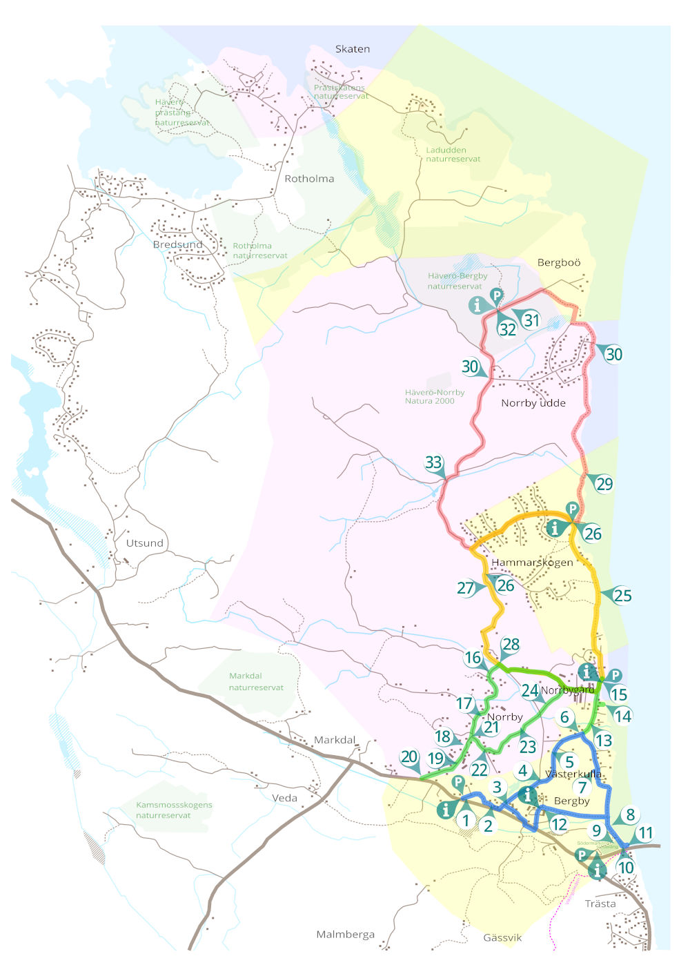
BERGBY-VÄSTERKULLA (Blue trail) ca 4,8 km
The blue trail is partly on an easier nature trail. Accessible for everyone on foot and by bike. Less suitable for strollers, walkers or wheelchairs.
- Bergby Skola (village school). Information board with map, parking lot.
- Bergby Handel (village shop)
- Västerkulla village
- Västerkulla farm
- Bergby mill
- A Roslagen farmhouse
- Bergby anti-aircraft battery
- Bergby beach
- Södermarken meadow
- Trästa bridge. Information board with map, parking lot. Connection to ”Vikingaleden” (St Olavs Waterway, or The viking trail).
- The boarder mark
- Bergby Gård. Information board with map, parking lot.
NORRBY (Green trail) ca 4,8 km
The green trail runs on roads. Accessible for everyone on foot and by bike, with stroller, walker or wheelchair.
- The water mill
- Bergby pier
- Norrbygård. Information board with map, parking lot.
- Byängen
- Mellangården
- Linbäcken (flax preparation site)
- The dairy cows
- Norrby crossroads
- Prästgårdsbacken (the rectory hill)
- Södergårdarna
- Ancient remains
- Electricity
HAMMARSSKOGEN (Yellow trail) ca 7 km
The yellow trail is mainly on roads. Accessible to everyone on foot as well as bicycles and strollers. Rollators and wheelchairs work with a little help.
- Oxberg
- Hammarskogen. Information board with map, parking lot.
- Kolbotten & Viktoriastugan (residues from charcoal production)
- The boatswain’s cottages
BERGBOÖ (Red trail) ca 13 km
The red trail mainly follows nature trails. Accessible to everyone on foot. Not suitable for bicycles, strollers, walkers or wheelchairs.
- Kvarnbacken (the mill hill)
- Norrby Udde
- The mines
- Häverö-Bergby nature reserve. (County Administrative Board sign) Information board with map, parking lot.
- The forestry